For a long time, our leaders have taken Nigerians for a ride, quoting astronomical amounts of money for delivering nothing. One major reason for this is that we had no way of knowing more than they told us. We relied on NTA News to tell us what our Government was doing with our funds….and we have all learnt how effectivet that is. But thanks to blogs, Twitter, Facebook and wikileaks…things are changing, and I suspect our country will never be the same. The first example of this was while NTA tried to deceive the public with its quietude reporting of the Independence day celebrations, images of the bomb blasts in Abuja were being viewed all over the world.
One more tool has just been added to our armoury of holding our leaders accountable.
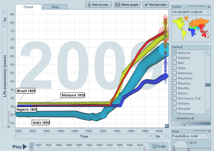
An amazing phenomenon is spreading around the world. People are finding ways to present data in ways that make them more accessible to people, enabling them to use this as advocacy tools. One man that has become a folk hero is Professor Hans Rosling whose TED Talk has received one of the most views ever. He founded a website called Gapminder that is literarily revolutionising our relationship with data. With software that brings data to life, we can follow our development (or lack of it) over time. This map below will show how we have done in terms of one of the most widely accepted indices of development; life expectancy. It not only shows how badly Nigeria (dark blue) has done measured against Brazil, India and Malaysia, it also shows within that how badly we did in the dark military yeas of the Babaginda/Abacha regimes. This is the new power of data. Next time I see our Minister of Health – this is what I will show him. You should too!
Now something amazing is also happening in Nigeria with the The Nigerian LGA GEodemographic Classification System and profiler (NIGECS) . This geodemographic classification system is an attempt to simplify a large and complex body of information about people, where and how they live, work or recreate.
At present, the Nigerian LGA classification system encapsulates spatially referenced datasets for the year 2006 sourced from the National Bureau of Statistics (NBS) for each of the 774 LGAs in the country. NIGECS is the first interactive repository for geographical and statistical information about the 774 LGAs in Nigeria. Find some of the health data below – showing access to public hospitals in 2006. You can immediately see the inequities in access in the country and one would expect a government to use this data to plan for the provision of health care in the country.
The beauty of this tool is that once your data is geographically referenced, you can change the data and produce maps needed to understand how our country is evolving.
This website has been put together by Dr Adegbola Ojo who has a PhD in Geography from the University of Sheffield. Dr Ojo is Lead Consultant in Development Studies, Informatics and ICT at the African Higher Education and Research Observatory (AFRIHERO), Sheffield, U.K. He is also Lead Consultant at Global Strategic Services and Training (GlossTra), Sheffield, and a researcher at the Head Office of Skills for Justice, Sheffield, U.K.
If I were the Minister of National Planning – I would camp outside Dr Adegbola’s home until he comes home even if it takes paying him the humble salary of a distinguished senator. I would do everything it takes…to get him to deploy his expertise in the service of our country…
This will probably not happen, as our leaders prefer that we stay in the dark….
Never doubt that a small group of thoughtful committed people can change the world; indeed it is the only thing that ever has…Margaret Mead


